What’s new in KeyTERRA-FIRMA?
KTF 9.6637
6 November 2026
- New platform BricsCAD V26 added (KTF 9.6637)
KTF 9.6537, 9.6437, 8.6337, 8.6237, 9.2637, 9.2537, 9.2437, 8.2337, 8.2237
29 August 2025
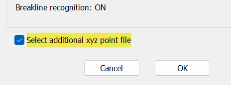
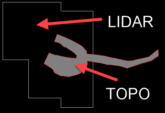
- ZTV updated to be able to work with very large ground models.
- Ground model creation from drawing entities
- Added option to use an additional xyz point file when creating the ground model directly from the drawing entities.
- This enables easier large ground model creation where, for example, the project area data is of a TOPO survey and surrounding landscape is based on LIDAR data.
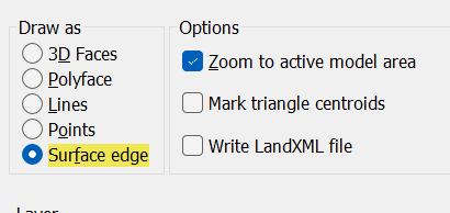
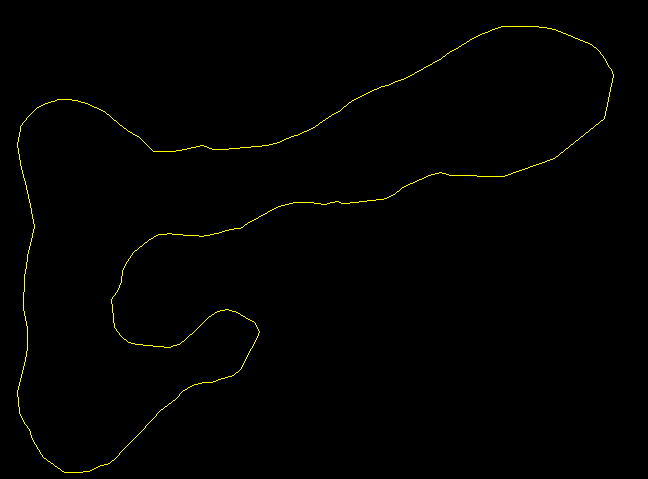
- Ground model import into drawing
- Added option to draw the surface edge only.
- Handy for very large models when you don't want to draw millions of triangles in drawing but want to see the model extents.
- Improved menu item Ground Modelling, Create model, From 3D Faces: Significant speed improvement with larger 3D Face sets
- Minor bug fixes: Snap/esnap sticking problem; Cross sections missed some areas with non-continuous surfaces; Ground model selection dialog displayed wrong file size with very big models
KTF 9.6536, 9.6436, 8.6336, 8.6236, 9.2636, 9.2536, 9.2436, 8.2336, 8.2236
9 May 2025
- New platform AutoCAD 2026 added (KTF 9.2636)
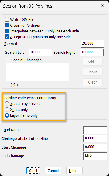
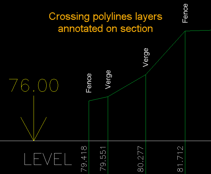
- Section creation from 3D Polylines
- Added option to annotate by polyline layer in addition to Xdata
- Those layer names can be annotated on the sections making the sections easier to read.

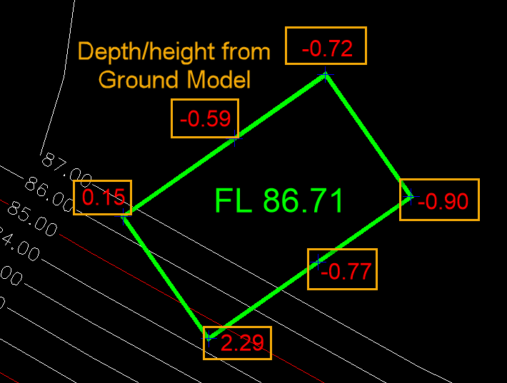
- Ground model level/gradient interpolation
- New information added to show the vertical difference between the picked point and Ground Model
- This allows, for example, to show the height/depth at plateau corners or at random points.
- Improved menu item Ground Modelling, Management and Relating, Apply adjuster Z values (was slow with big models)
- Fixed Pipe csv output from Gravity Pipes bug (used to crash sometimes)
- Fixed KTF, Annotate and Enhance, Symbol features, Tree annotation (used to crash)
KTF 9.6535, 9.6435, 8.6335, 8.6235, 9.2535, 9.2435, 8.2335, 8.2235
15 November 2024
- New platform BricsCAD V25 added (KTF 9.6535)
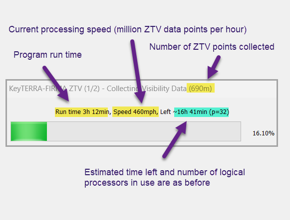
- ZTV improvements
- Speed improvement with secondary pass, analysing generated ZTV points. Speed increase more noticable with large data sets
- The progress dialog shows more information and is robust with large data sets
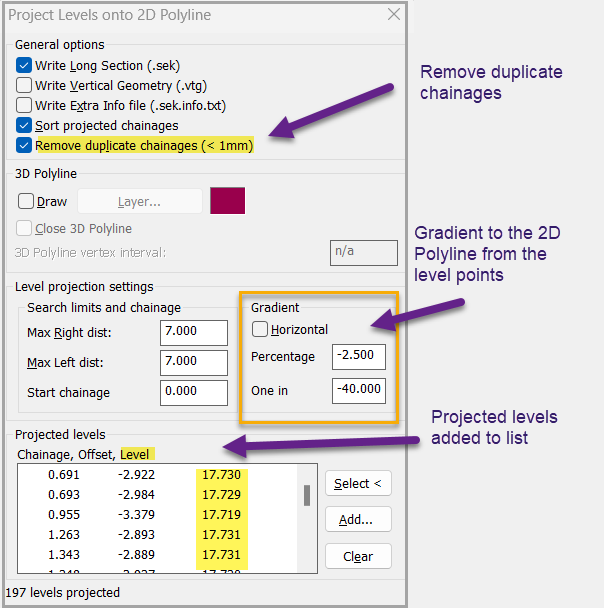
- Project levels onto 2D Polyline
- Minor improvements (Licence and update internet connections updated, startup unecessary message fixed, specifying local folder bug fixed, network licence allows more relax settings, section from 2D Polyline crossing 3D Polylines now accepts 3D Polyline as the reference string)
KTF 9.6434, 8.6334, 8.6234, 9.2534, 9.2434, 8.2334, 8.2234, 8.2134
21 June 2024
- ZTV Bug fix ZTV speed was slowed down cosiderably in past 2 releases, now fixed.
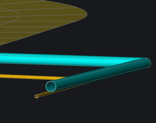
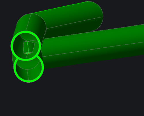
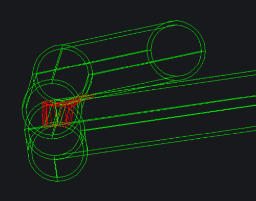
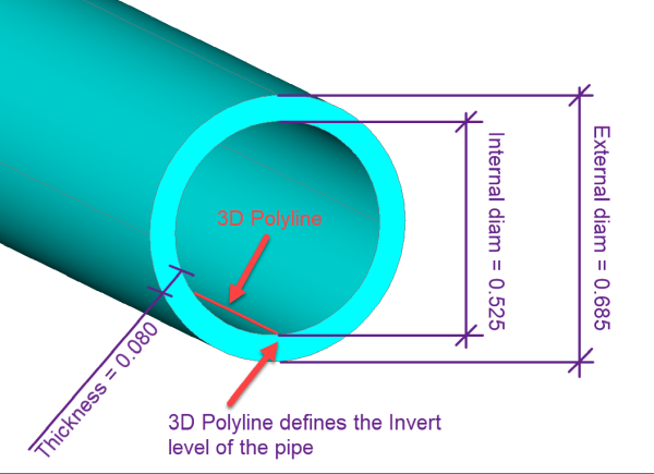
- New menu item 3D Polylines, Polylines to Pipes (Available in AutoCAD in 2024 and 2025 and in BricsCAD V22, V23 and V24 platforms)
- Convert 3D Polylines to 3D Solids for visualisation
DN525 pipe dimensions (without socket)
Surface and Faul water pipes
Underground pipes
Clash detected with INTERFERE command
KTF 9.6433, 8.6333, 8.6233, 9.2533, 9.2433, 8.2333, 8.2233, 8.2133
14 May 2024
- New platform AutoCAD 2025 added (KTF 9.2533)
- Rare ground model creation bug fixed (happened with very small data set with a breakline in straight line)
- Minor improvements (Number of decimals option added to AutoTAD and Slope Define,
added chainages for river section outputs, some wrong defaults in file dialogs fixed)
KTF 9.6432, 8.6332, 8.6233, 9.2432, 8.2332, 8.2232, 8.2132
21 November 2023
- New platform BricsCAD V24 added (KTF 9.6432)
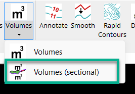
- Volume calculations
- Added Sectional Volume, end area calculations
Sectional volumes
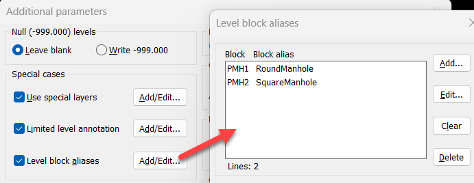
- Survey/Topo import
- Added Level Block Aliases for flexibility and clarity
Block aliases
- Minor improvements (Relaxed some forced entity snap setting when in some KTF functions,
added time estimate to grid mesh generating and fixed few minor bugs)
KTF 8.6331, 8.6231, 8.6131, 9.2431, 8.2331, 8.2231, 8.2131
19 July 2023
- Quick fix: Due to compilation settings error KTF ground modelling wasn't able to make model from large amout of data points.
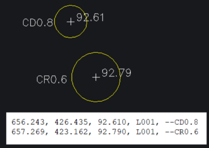
- Survey/Topo import
- Added option to specify tree bole layer extension (or leave empty)
- Added new comment codes --CR and --CD, Circle with Radius or Diameter
New draw Cirle comment codes
KTF 8.6330, 8.6230, 8.6130, 9.2430, 8.2330, 8.2230, 8.2130
28 May 2023
- New platform AutoCAD 2024 added (KTF 9.2430)
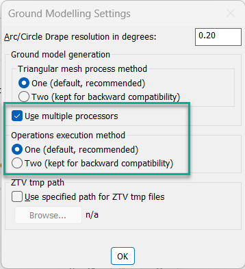
- Major improvement with Ground Modelling functions when working with large models
- Typical ZTV processing time halved
- Cross section creation time more than halved
- Active/passive assigning speed improved
- Use of multiprocessing with triangulation
Added ground modelling options
- General ZTV improvements
- ZTV progress progress bar and progress file made more informative
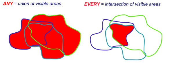
- Ground modelling, Management and relating, Combine visibility models(s) -> Added ANY/EVERY logic
Combine ZTV models logical options
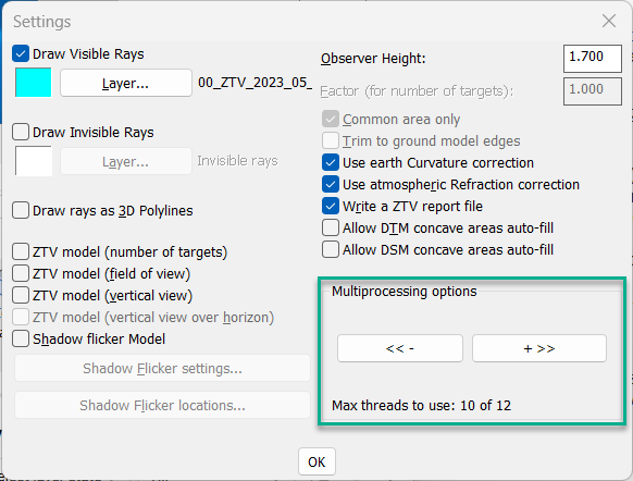
- Allowed Thread Load control when multiprocessing
ZTV multiprocessing control
- Survey/Topo import
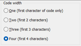
- Added support for three and four charcter coding
Four charcter coding
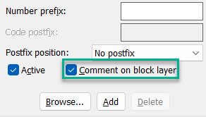
- Added option to insert comments onto the level block layer
Option for comment layer
- Levels, Levels onto 3D Polyline(s) -> Added option to remember point numbering
- Minor improvements to Gravity pipes manhole table, 3D Offfset and Rapid contouring stability and Network licensing client
- Minor bug fixes
KTF 8.6329 8.6229 8.6129 8.6029 8.5929, 8.5829, 8.2329, 8.2229, 8.2129, 8.2029, 8.1929, 8.1829
8 November 2022
- New platform BricsCAD V23 added (KTF 8.6329)
- Minor improvements (Added new option for Polylines to blocks function, enhanced LandXML alignment import, Improved Gridding model creation)
- Increased startup speed when opening drawings
- Rare file selection dialog bug for mergexyz function fixed
KTF 8.6228 8.6128 8.6028 8.5928, 8.5828, 8.5728, 8.5628, 8.2328, 8.2228, 8.2128, 8.2028, 8.1928, 8.1828, 8.1728, 8.1528
4 July 2022
- Quick fix 1: Coordinate input program nominal scale text field in dialog had an annoying bug showing some Chinese characters.
Program still worked fine but this field was not updated correctly.
- Quick fix 2: Another bug stopping LIDAR data file conversion is now fixed. (.asc convert to .xyz) .
KTF 8.6227 8.6127 8.6027 8.5927, 8.5827, 8.5727, 8.5627, 8.2327, 8.2227, 8.2127, 8.2027, 8.1927, 8.1827, 8.1727, 8.1527
19 May 2022
- New platform AutoCAD 2023 added (KTF 8.2327)
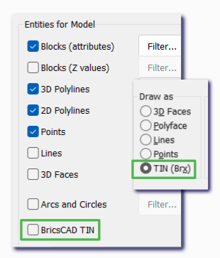
- Added BricsCAD TIN surface read/write options
BricsCAD TIN surface read/write options
- Small improvements to some functions
- Gravity Pipes, .mdx import -> more tolerant of imported file errors
- Levels, Levels onto 3D Polyline(s) -> Added options after aligning text to polyline to Accept, Rotate texts 180 deg or Undo
- File utilities, .txt Co-ordinate files, Import -> Added tree bole layer for tree blocks
- Design, Schedules and analysis -> Removed forced text style change from these functions
- Added 2 command line utility functions KTF_CHANGE_SCALE_FACTOR and KTF_CHANGE_NUM_OF_DECIMALS for convenience
- Few minor bug fixes (rare multiple kgm selection dialog error, topo import curve fitting not always working, draping very small arcs on ground model, vertical design/Level Diff mysterious bug fixed, entity color by elevation some sequences caused error fixed)
KTF 8.6226 8.6126 8.6026 8.5926, 8.5826, 8.5726, 8.5626, 8.2226, 8.2126, 8.2026, 8.1926, 8.1826, 8.1726, 8.1526
12 November 2021
- New platform BricsCAD V22 added (KTF 8.6226)
- Speed improvement when creating very large ZTV models
- Added Manhole/Pipe diagram to Translators, Micro Drainage, Pipe Network Tools
Manhole/Pipe diagram
- Added mark differences option to Levels, Levels onto 3D Polyline
3D Polyline Difference
- Survey import, Rectange from 2 points (X code) made more flexible
X code samples
- Added new file formats to File utilities, .txt co-ordinate files, Output from Block Attributes
- Added Z filtering option and allow multiple file generation to File utilities, .xyz co-ordinate files, Merge and Extract
- Added average two ground model option to Ground modelling, Management and relating, Landfill settlement
KTF 8.6125 8.6025 8.5925, 8.5825, 8.5725, 8.5625, 8.2225, 8.2125, 8.2025, 8.1925, 8.1825, 8.1725, 8.1525
12 April 2021
- New platform AutoCAD 2022 added (KTF 8.2225)
- Added support for superimposing section-non-linear features on long section. This is when a feature "folds onto itself" when projected onto a section.
Non linear section projection
- Quick volume (onto flat surface) improved: Now any base level is accepted
- Minor bug fixes + general enhancements
KTF 8.6124 8.6024 8.5924, 8.5824, 8.5724, 8.5624, 8.2124, 8.2024, 8.1924, 8.1824, 8.1724, 8.1524
4 November 2020
- New platform BricsCAD V21 added (KTF 8.6124)
- Added text orientation options for marking the centerline chainages to make the annotations more readable
Text orientation
- Ground modelling speed improvement
- LandXML Ground Model input/output routine update
- General enhancements
KTF 8.6023 8.5923, 8.5823, 8.5723, 8.5623, 8.2123, 8.2023, 8.1923, 8.1823, 8.1723, 8.1523
19 April 2020
- New platform AutoCAD 2021 added (KTF 8.2123)
- Minor improvements to co-ordinate file input, water volume graph routine, digitise level program and misc. routines' default save path settings
- New Comment control code added --D[n] Decimals. Can specify the annotation decimal point accuracy at individual surveyed points
Comment code D
KTF 8.6022 8.5922, 8.5822, 8.5722, 8.5622, 8.2022, 8.1922, 8.1822, 8.1722, 8.1522
16 December 2019
- Important bug fix: The version 8.xx21 19 November 2019 had a bug causing some file selection dialogs freeze, this has been fixed in this version.
KTF 8.6021 8.5921, 8.5821, 8.5721, 8.5621, 8.2021, 8.1921, 8.1821, 8.1721, 8.1521
19 November 2019
- File selection dialog enhanced: Folder navigation added (and shortcut to extended file information for section files)
KTF File selection dialog
- Default folder set to active drawing folder for most KTF file input/output functions.
KTF 8.6020 8.5920, 8.5820, 8.5720, 8.5620, 8.2020, 8.1920, 8.1820, 8.1720, 8.1520
28 October 2019
- New platform BricsCAD V20 added (KTF 8.6020)
- KTF Ribbon interface added
KTF Ribbons
- Minor improvements to Code Find, Level Adjust and Export Polylines to .txt file routines (accept partial find, allow longer text, no case sensitive, add point numbers)
- New menu item Translators, Export Ground Model, Export to .stl file. Export ground model triangles to a simple triangle file.
- Export to csv (Comma Separated Value) file added to KTF co-ordinate file editor
Export to csv file
- Added Postfix option, a free text to be added to Code field when importing standard level blocks
Add text to Code attribute field
- Added option to read levels from picked text when digitising KTF level points. Select a 2D location then select text to specify the level
Pick text to add level
KTF 8.5919, 8.5819, 8.5719, 8.5619, 8.2019, 8.1919, 8.1819, 8.1719, 8.1519
10 June 2019
- New menu item Polyline utilities, Find small gaps. Marks locations where polylines don't snap exactly where they are supposed to. Finds both over and undershoots.
Gaps marked with red circles
- New menu item Sections, Browse/Find section(s). Find the original section file that the section in drawing is based on
Profile line on a section: Need to find the original section file
Scanning results
- Added a Find button to section selection dialog that lists all sections in a drive or folder.
List all sections in subfolders
- Autotad enhancement: Added Max and Min length filter
KTF 8.5918, 8.5818, 8.5718, 8.5618, 8.2018, 8.1918, 8.1818, 8.1718, 8.1518
25 April 2019
- New platform AutoCAD 2020 added (KTF 8.2018)
- Minor improvements and updates
KTF 8.5917, 8.5817, 8.5717, 8.5617, 8.1917, 8.1817, 8.1717, 8.1517
1 March 2019
- Ground modelling, Create Model. Added Smart Point Reduction. Ground model size can be reduced
by deducting level points selectively controlled with an adjustable vertical tolerance. Can result with considerably
smaller model.
Sample screenshots below of two models, both created from same data: dense level point grid and breaklines
Ground model triangles without Smart Point Reduction
Ground model triangles with Smart Point Reduction
- Sections, Create section from drawing entities, Levels along a 2D Polyline. Added an output file with detailed locational information
- Minor improvements and updates to section/river section routines
KTF 8.5916, 8.5816, 8.5716, 8.5616, 8.1916, 8.1816, 8.1716, 8.1516
3 December 2018
- New platform BricsCAD V19 added (KTF 8.5916)
- Ground modelling, Drape, Extrude Added support for subareas/dead areas
- Allow vertical 3D Polyline vertexes input as Target Points in ZTV
- KTF Ground Model file (.kgm) and Section File (.sek) selection dialog
1) Added option to Edit History so you can remove/change/add/re-order the previous file paths
2) Browsing folders now recognises unc path notation folders
- Improved compliance to latest EACSD file format (3.3) export
- Levels, Levels onto 3D Polyline(s) Added starting point number for inserted blocks (used to start always from number 1)
KTF 8.5815, 8.5715, 8.5615, 8.1915, 8.1815, 8.1715, 8.1515
27 June 2018
- Translators, Micro Drainage, Pipe Network Tools:
1) Added pipe and bedding material to supported data. If present this info will be read directly from .mdx file. Long section annotation expanded to include this data.
2) Long section annotating process simplified by no longer requiring .sws of .fws files.
-
Added functionality to automated Tree drawing in Survey Input with new Comment Control Codes. Makes tree observations with reflectorless equipment easier:
--3 Three observations per tree with a reference to the observation station
--4 Four observations per tree
--5 Five observations per tree
- Section drawing presentation slightly enhanced
KTF 8.5814, 8.5714, 8.5614, 8.1914, 8.1814, 8.1714, 8.1514
1 May 2018
- New platform AutoCAD 2019 added (KTF 8.1914)
- Land Survey, Stations, .stn Station file Editor enhanced
- Translators, Micro Drainage, Pipe Network Tools: Expanded pipe data manual editing and improved the .mdx file import function.
- KTF licence made more flexible with added software licesing options
KTF 8.5813, 8.5713, 8.5613, 8.1813, 8.1713, 8.1513
24 January 2018
- Contour labelling made to avoid overwriting the labels
- Minor improvements and bug fixes
KTF 8.5812, 8.5712, 8.5612, 8.1812, 8.1712, 8.1512
6 November 2017
- New platform BricsCAD V18 added (KTF 8.5812)
-
Added more detailed analysis to ZTV program. It is now possible to show which Targets are visible from study area by hovering pointer over the area.
-
Added ZTV Target Filter to Z value Analysis. Enables to show selectively which Targets are visible by coloring areas where selected Target(s) are visible from
KTF 8.5711, 8.5611, 8.1811, 8.1711, 8.1511
13 September 2017
-
Added an automatic visual barrier option to ZTV program. Visual barriers can now be interpolated directly from a Digital Surface Model.
- Further controls added to Micro Drainage pipe layout and section annotations
KTF 8.5710, 8.5610, 8.1810, 8.1710, 8.1510
18 July 2017
- River section output improvements.
- General minor bug fixes
KTF 8.5709, 8.5609, 8.1809, 8.1709, 8.1509
7 June 2017
- Enhanced ground modelling. Triangulation is now faster, especially with large amount of breaklines.
-
Ground modelling and Sectioning now use optional subfolders for storing the .kgm and .sek files to ease the file housekeeping.
- Added function in Configuration Dialog to import KTF settings from previous versions
- Added option to menu item Land Survey, Stations, .stn Station file Editor: Import/Export a .csv file.
- Added annotation detail to menu item Translators, Micro Drainage, Pipe Network Tools: Pipe invert levels
-
Added functionality to Comment Control Codes:
--Z Null level; Sets the point as null level but retains it's Z value
- Added option to manually enter level for picked point in menu item 3D Polylines, from Picking levels
- Allow multiple OS Land Profile Plus file selection in one go when converting to XYZ format.
- Added option to menu item Ground Modelling, Analysis and Colour mapping, Z value: Draw True Colour solids onto separate layers for enabling selective layer freezing etc.
- New platform AutoCAD 2018 added (KTF 8.1809)
KTF 7.5760, 7.5660, 7.5560, 7.5460, 7.5360, 7.1760, 7.1560, 7.1360 and 7.1060
2 November 2016
- New platform BricsCAD V17 added (KTF 7.5760)
KTF 7.5660, 7.5560, 7.5460, 7.5360, 7.1760, 7.1560, 7.1360 and 7.1060
19 September 2016
-
Menu item Ground Modelling, Create Model, From .xyz file Gridding enhanced. Added Z filtering for input data.
- Menu item File utilities, .xyz Co-ordinate files, Merge and extract enhanced. Added Co-ordinate shift options.
-
Menu item Design, Strings, Gradient to 2D Polyline from Master String enhanced. Added support for specify multiple gradient chainages and also an option to include master string vertical geometry apex points to interpolated chainage points.
-
Added functionality to Comment Control Codes:
--B Break curve fitting; Ends and re-starts curve fitting
--J Join new polyline feature to previous polyline's last point
--H Add a point to current polyline by a number reference, before the point
--R Add a point to current polyline by a number reference, after the point
- Menu item 3D Utilities, Convert 2D entities to KTF levels enhanced. Now runs faster.
KTF 7.5659, 7.5559, 7.5459, 7.5359, 7.1759, 7.1559, 7.1359 and 7.1059
11 April 2016
-
Micellaneous enhancements and bug fixes including:
- Large number of cross sections are now drawn faster
- Minor fixes for Move To and Linear Feature to Blocks routines
- Added support for less usual jpeg file format when extracting GPS co-ordinates
- New platform AutoCAD 2017 added (KTF 7.1759)
KTF 7.5658, 7.5558, 7.5458, 7.5358, 7.1558, 7.1358, 7.1058 and 7.0058
10 February 2016
-
Menu item Sections, Micellaneous, Crank Decenders enhanced. Automatic option added.
- Autotext shifting added to Cross Section draw routine
- EEBY section file conversion (River routines) improved
KTF 7.5657, 7.5557, 7.5457, 7.5357, 7.1557, 7.1357, 7.1057 and 7.0057
1 November 2015
- New platform BricsCAD V16 added (KTF 7.5657)
- New menu item Ground Modelling, Create model, Strata model. Creates a smooth strata model by combining sparse borehole info with more detaild surface ground model.
KTF 7.5556, 7.5456, 7.5356, 7.1556, 7.1356, 7.1056 and 7.0056
3 August 2015
- Bug fix for version 7.xx55: Ground Modelling, Create section had a bug that caused a non-zero start chainage to "double" in section file.
- Added water volume calculation by elevation option: Ground Modelling, Volumes.
- New menu item Ground Modelling, Create model, Analysis and Colour mapping, Water volume / level graph. Draws a graph showing above functions' results
- New menu item 3D Polylines, Ground model intersections. Mark where 3D Polyline(s) "break into / out of" model.
- Added layer definition for draw and superimpose sections: Sections, Draw Section and Draw Cross Sections. Now the actual section line's layer can be defined without tying it to the section Box + Line structure.
-
Added flexible coding for Co-ordinate file input: Comment Control Codes. You can now place following commands anywhere in the comment field:
--F Start curve fitting
--S Stop curve fitting
--E End polyline
--C Close polyline
--T followed by trunk and spread diameters, e.g. --T0.15,15: Draw Tree as usual but more accurately
--A followed by trunk diameter and spread parameters, e.g. --A1.15,4,3,5,6 -> Draw 1.15m tree trunk and Asymmetric spread as splineish polyline 4m north, 3m east, 5m south and 6m west from tree
KTF 7.5555, 7.5455, 7.5355, 7.1555, 7.1355, 7.1055 and 7.0055
7 July 2015
- New menu item Ground Modelling, Create model, Merge two models. Joins two models together e.g. a site survey model in the middle of a larger OS DTM model of the surrounding landscape for ZTV study.
- New menu item Ground Modelling, Analysis and Colour mapping, Visual barriers from LIDAR model: Part of process to automatically add all visual barriers to a ZTV study.
- Ground Modelling, Analysis and Colour mapping, ZTV: Added option to draw all visual barriers at their barrier height as Z value. (Then you can colour barriers according to their heights for example)
- Ground Modelling, Analysis and Colour mapping, ZTV: Added option to draw target points as 3D Points.
- Ground Modelling, Embankments: Added option for Benching.
- Design, Horizontal, Extract geometry: Added option to export 2D and 3D geometry into a LandXML file.
- Design, Vertical, Extract geometry: New file output option, .vta file.
- 3D utilities, Underground Services: Now detects service conduit clashes in 3D.
- File utilities, Add Text from ASCII file into drawing: Added option to draw the text as MText or Text.
- Added flexibility to enable / disable selected auto-corrections when KTF starts.
KTF 7.5554, 7.5454, 7.5354, 7.1554, 7.1354, 7.1054 and 7.0054
6 March 2015
- New menu item Ground Modelling, Create model, Linear surface. Makes a ground model along a 3D Polyline
- Added ISIS output when creating an EACSD, River cross section data file.
KTF 7.5553, 7.5453, 7.5353, 7.1553, 7.1353, 7.1053 and 7.0053
2 January 2015
- New menu item Translators, Read GPS locations from photos. Read embedded GPS Co-ordinate information from selected .jpg images and write Co-ordinate file(s). KTF's Import .txt co-ordinate file function will optionally draw the locations into CAD and mark them with a camera symbol block that can be clicked to view the photos.
- Added dynamic Z display to Interpolate Levels program. When hovering over a ground model the Z value and gradient under cursor location is shown.
- Micro Drainage tools enhanced: Added support for .mdx files, Improved manhole schedules, Added option to draw pipes and backdrops when annotating network, Automated .lsc file generation for superimposing pipe runs onto sections and some other minor improvements
KTF 7.5552, 7.5452, 7.5352, 7.1552, 7.1352, 7.1252, 7.1052 and 7.0052
15 October 2014
- New platform BricsCAD V15 added (KTF 7.5552)
- Added areas to Polyline lengths by layer menu item
- Annotating special chainages on long section: Added option to mark the special chainage IDs over the section line
KTF 7.5451, 7.5351, 7.1551, 7.1351, 7.1251, 7.1051 and 7.0051
17 September 2014
- Added a new parameter to Long Section draw program: Fixed Gap before and after section data
- Added functionality to River module’s EACSD output
- Minor improvements in Gravity Pipe network annotations and Building face projection programs
KTF 7.5450, 7.5350, 7.1550, 7.1350, 7.1250, 7.1050 and 7.0050
10 July 2014
- New menu item Design, Vertical, Gully locator. Locate a gully within a specific area by adjustable gradient tolerances to existing and / or design 3D Polylines like road channels, buildings etc.
KTF 7.5449, 7.5349, 7.1549, 7.1349, 7.1249, 7.1049 and 7.0049
28 May 2014
- Added Finished Floor Level option to Levels, Levels onto 3D Polyline(s) and Ground Modelling, Interpolated Levels, Picked locations (and gradients)
- New platform AutoCAD 2015 added (7.1549)
KTF 7.5448, 7.5348, 7.1348, 7.1248, 7.1048 and 7.0048
15 April 2014
- New menu item Polyline utilities, Trim polyline by another polyline
- New menu item Sections, Miscellaneous, Write .csv file from .sek file
- River module’s EACSD output format updated to new Environment Agency version 3.2
- Added precision control to Manhole Schedules
KTF 7.5447, 7.5347, 7.1347, 7.1247, 7.1047 and 7.0047
31 Jan 2014
- New Co-ordinate grid output from model
- New online help system replacing old one
- Menu has been re-organised
- New menu item Land survey, Annotate levels on elevation
KTF 7.5446, 7.5346, 7.1346, 7.1246, 7.1046 and 7.0046
21 November 2013
- New platform BricsCAD V14 added (KTF 7.5446)
- Shadow Flicker analysis added to ZTV.
- Menu item Project building face observations enhanced to work with Point Cloud data
KTF 7.5345, 7.1345, 7.1245, 7.1045 and 7.0045
23 May 2013
- New platform BricsCAD 64 bit added.
- New menu item Design on Cross Sections Edit Cross Sections and View Services in a dialog.
- New menu item Drape onto a sloping surface Simplified version of Drape onto Road Surface
- Gradients to 3D Polylines improved to have added control for number of decimal places
- Cross sections from 3D polylines improved to 1) remember the last special chainages used and 2) a "Pick <" button added.
KTF 7.5344, 7.1344, 7.1244, 7.1044 and 7.0044
28 March 2013
- Added support for Windows 8 for both 32 and 64 bit platforms.
KTF 7.5343, 77.1343, 7.1243, 7.1043 and 7.0043
14 December 2012
- New menu item 3D Polyline curve fit Curve fit 3D Polylines similar way as 2D Polylines.
- New menu item Combine visibility models Add ZTV models together.
- New menu item Drape Wind Turbine Drop a 3D block presenting a Wind Turbine onto a ground model.
- Added functionality for Draw features on section Added Electric Pylon and Wind Turbine.
- 3D Polyline offset function improved to close the offsetted polyline when necessary.
KTF 7.5342, 7.1342, 7.1242, 7.1042 and 7.0042
17 October 2012
- KTF 7.5342 to work with BricsCAD V13.
- Land Survey, .dat file editor updated to use wider set of degree symbols.
- ZTV 3D Polyline input as Target Points improved to read the String Names automatically from Xdata.
- ZTV now shows progress bar for single point analysis too.
- EA River Section output program’s cross sections viewing improved to filter out non-essential polylines.
KTF 7.1341, 7.1241, 7.1041 and 7.0041
20 July 2012
- New menu item 3D Polylines, from 2D Polyline and design on section draws 3D polyline directly by picking a 2D polyline and a vertical design on a section.
- Menu item Relationship from Master String to 3D Polyline enhanced to add the chainages sorted in decending offset. Helps to pinpoint the chainage where the neighboring polyline is (horizontally) closest to the main.
- Menu item Ground modelling, Average level updated with a progress bar so it no longer seem to "freeze" when working on a large model.
- Our contact information updated to the new office address in Henley-in-Arden and telephone number 01978 225497.
KTF 7.1339, 7.1239, 7.1039 and 7.0039
28 May 2012
- KTF ported to run on a new CAD platform: AutoCAD 2013
- New menu item Annotate and Enhance, Symbol features, Tree annotation annotates individual tree symbol blocks.
KTF 7.1238, 7.1038 and 7.0038
17 Febuary 2012
- New menu item Translators and OS, OS, OS Open Data, Create OS Land-Form Panorama file interpolates, at user defined grid size, points onto a ground model and stores them to a OS/ESRI/Tuflow ASCII .asc file
- New menu item Sections, Co-ordinates of picked location annotates spatial co-ordinates of the section chainage or offset on section drawing at picked locations.
- New menu item Annotate and Enhance, Height difference from two 3D Polylines marks the level difference - usually between kerb and channel strings.
- New menu item Translators and OS, LandXML, Import from LandXML as Centerline draws horizontal geometry from a LandXML file and converts it to .Hzg file format.
KTF 7.1237, 7.1037 and 7.0037
20 January 2012
- KTF 7.1237 to work with Bricscad V12 (12.1.12 or later Bricscad required)
- Introducing Secure Dongle, new Hardware Locks that work directly in 64 bit operating systems. No more local NLM required.
- New option when importing Ground Model triangles: Lines
KTF 7.1136, 7.1036 and 7.0036
17 August 2011
- Added Vertical Analysis to ZTV answering questions: Visible?, How much is visible? and How much is visible above skyline?
- New function: Export cross sections to a .csv file KTF, Sections, Miscellaneous, Write .csv file from cross sections for section data spreadsheet analysis / modifications for example
- New function: Convert above file to a KTF cross section file KTF, Sections, Miscellaneous, Write .sek file from .csv file to redraw / superimpose sections that have been modified
- Added optional Level and Code prefix to Co-ordinate input
- KTF’s Section, Ground Model and Geneal File Selection dialogues now have a "History" button that eases folder navigation
- Many functions that used to seemingly "freeze" CAD while still working now don’t freeze and show progress bar
- Added Client Network Licence Manager to ease NLM server changes etc. common Network Licence maintenance tasks
- KTF menu improvements
KTF 7.1135, 7.1035 and 7.0035
12 May 2011
- Introducing of KTF .11 in version numbering for Bricscad V11 platform
- Cross sections now enabled to use Crank Decenders operation
- New menu item Design, Strings, Gradient to 2D Polyline from Levels/3D Polylines to improve ease of use when working from thresholds
- New menu item Design, Schedules and analysis, From a .csv file to work like Schedules and analysis, 3D Polyline (.csv) but starting with .csv file.
- Drawing 3D polylines directly from section(s) option added to program KTF, Sections, Create sections from drawing entities, Polyline(s) on Section or Cross Section(s)
- Ground model creation with breaklines speed improved, can create some models in 13% of the time it took previously (in one test: 12 minutes now, over 1.5 hours before). Time improvement will vary depending on source data.
KTF 7.1034 and 7.0034
4 March 2011
- Version for Bricscad V11 Pro
- Local dongle recognised (no NLM required) for AutoCAD 2010, 2011 and 2012 64bit
- Integrating some minor changes to pre-release "33", hence jumping from 32 to 34.
- Some general enhancements added to program code to speed up ZVI / ZTV analysis.
- Added Multi Core Processing to ZVI / ZTV analysis.
- Added Progress Bar to ZVI / ZTV analysis and to Ground Model creation.
- When selected centreline is 3D polyline Single string defined by offset and gradient, Assign by gradient to 2D polyline and Assign to 3D polyline with tolerance now give an option to accept the 3D Polyline’s levels as vertical geometry.
KTF 7.1032 and 7.0032
22 December 2010
- Added decimal control for Ground Modelling, Interpolated levels, Picked points (and gradients)
- Added Solar Reflection sub menu item with two functions: Draw panel and Reflection. To be used in conjunction with ZVI / ZTV analysis to see if solar reflection happens.
- New special code added to KTF .txt Co-ordinate file input Tagged Information Block.
- New menu item Rivers, Digitise river photo locations added. Part of functionality to export river survey data to the Environment Agency’s new EACSD format.
KTF 7.1031 and 7.0031
15 November 2010
- ZVI user interface improvements.
- Added an option to change the layer of found entities in Code and number search.
- Number of River functions improvements.
KTF 7.1030 and 7.0030
23 August 2010
- New option added to annotate the elevation of picked point on a section with a triangle for menu item Sections, Chainage and Level of picked point.
- New menu item Survey, Annotate levels on elevation added. Adds elevation markers to projected building elevation.
- Added a new option when analysing ZVI results with Z value colour analysis: Draw Polygons for hatching.
- New menu item 3D Utilities, Draw steps added. Draws steps from one elevation to another.
- Enhanced function Sections, Create sections from drawing entities, Levels projected onto 2D polyline so that the 3D polyline Draw option now draws the 3D polyline along the centreline, not just joins the inputted level points.
- Eliminated the default folder change which sometimes happened when CAD performed an Autosave.
KTF 7.1029 and 7.0029
11 May 2010
- New sub menu Translators and OS, OS, OS OpenData added added to support OS free downloadable content import to CAD. Initial supported formats are Street View and PANORAMA.
- Added a new option to have horizontal floor level at highest elevation and horizontal roof for menu item Ground Modelling, Drape, Extrude
KTF 7.1028 and 7.0028
29 April 2010
- New sub menu Help, Network Licencing added. Control and verify NLM, dynamic licence release and acquiring.
- Added new dimension to menu item Land Survey, Project building face observations: Enables wall / cliff face monitoring for example.
KTF 7.1027 and 7.0027
20 April 2010
- New menu item Sections, Add to section(s), Levels and 3D Polylines from plan added. Projects 3D entities next to a section line in plan view to a section drawing. A bit like house face projections but more simple.
- Added new annotation option to menu item Sections, Chainage and level of picked point: Mark levels with arrows (triangle) pointing to the level
- One to 1250 scalebar added
- New menu item Rivers, Create drainage channel cross sections added. Works like river sections but sections are not in "reverse" as with River sections.
KTF 7.1026 and 7.0026
11 March 2010
- New menu item Ground Modelling, Drape, Move to High Level added. Moves closed polylines to the highest level on the model over the polylines’ areas.
- New menu item Rivers, River section input, Convert EEBY to KTF section file added. Adding flexibility to KTF with another format to import to KTF.
- KTF tested to install and run on new AutoCAD 2011 platforms.
KTF 7.1025 and 7.0025
4 February 2010
- New menu item Sections, Dimensions added. Easy way to inspect and annotate horizontal and vertical dimensions on sections.
KTF 7.1024 and 7.0024
22 November 2009
- New menu item Sections, Volume added. Calculating volumes from cross sections with end area method. Handy for quick volumes while designing on sections and good for providing calculation details.
KTF 7.1023 and 7.0023
18 August 2009
- New menu item Sections, Add to Sections, Vertex codes added. Designing and analysing roads, rivers and even landfill sites on cross sections made much easier.
- Drawing cross sections has a new option: Force zero start offset and trim to size. Helps producing cross sections that comply with EA standards.
KTF 7.1022 and 7.0022
23 July 2009
- KTF now runs on a new platform: Bricscad V10 Pro
- Zones of Visual Influence menu item enhanced by adding Field of View analysis to help visualize the actual visibility on loaction.
- Gradient annotation added to long- and cross fall analysis.
KTF 7.1021 and 7.0021
22 June 2009
- Primary Support Folder introduced to help with network installations. This allows system administrators to keep survey and co-ordinate input routines’ code lookup tables etc. in one folder in the network.
- Menu item Rivers, Create cross section file (.sek) modified to include 3D Polyline vertices as well as spot levels and the sections are now organised to work in a downstream direction.
- Key Code web link points now to right place
KTF 7.1020 and 7.0020
14 May 2009
- New menu item Bund design from volume to calculate bund parameters to accommodate a specified volume.
- New menu item 2D utilities, OS Imagery to insert OS 1km. x 1km. .jpg at location defined by a picked point.
- Added River function to create cross section file and .csv file from centerline, crossing 2D Polylines and spot levels.
- Added Rivers menu item - Overlay design now included in Main Design.
KTF 7.1019 and 7.0019
6 May 2009
- Added code lookup table facility to Create Level Data file from 3D Polylines with default codes LB, LT, DB, CLB, RT and RB for river sections.
- New menu item Bed design to cross sections - adds horizontal lines to each section at a level from a Vertical alignment design and draws the embankments.
- Added Invert Levels etc. to a section - new menu item Add to section. Added an option to import Invert Levels etc. from a .dat file.
- New level data input format added to the Cross section data file Editor for .csv files (in order level, code, chainage, offset).
KTF 7.1018 and 7.0018
14 March 2009
- KTF is now available in AutoCAD 2010 platform (version 7.1018)
- New Translators menu item to extract River centreline and cross section location data.
- Rapid and Multisections now include a function to select a number of individual section files and write one cross section file to enable much faster drawing outputs
KTF 7.0017
6 March 2009
- Sections menu item to get Invert Levels etc. from plan location and then draw on Long Section.
- Installation option to make multiple shortcuts to work with two or more AutoCAD versions.
- Set nominal scale factor from configuration dialogue.
- New option added to swap E and N co-ordinates in LandXML conversion to .kgm model
KTF 7.0016
23 December 2008
- Codefind function now supports MText and filters the text more intelligently for non-numeric characters.
- Z value analysis program reports volumes on different cut levels or depths.
- Some horizontal geometry functions now can see in "shadow corners"
KTF 7.0015
15 December 2008
- ZVI visual barrier enhancement: 3D Polylines can now contain unlimited number of elements, not only one as before.
- New menu item in Translators: Convert USGS SRTM BIL data into KTF readable format. That’s Space Shuttle level data, available free and covering the whole of the UK.
KTF 7.0014
1 December 2008
- Section drawing: Added "Vertical exaggeration" field.
- Section drawing: Added a toggle for auto datum change prompting
- Contouring: Added option to align the contour labels to uphills or not (if not: align in readable angle)
- Draw 3D Polyline(s) from .sek file: Added option to mark chainages as it’s drawing 3D polyline(s) from .sek file
- Volume calcs: Made the "Suggest to optimise" suggestion more accurate in some rare cases
- Volume calcs: Differencial model creation now has an option to make "True Model", an accurate presentation of cut and fill depths
- Added update checking in KTF menu
|